River Cam, Cambridge to Grantchester Paddle Trail

River Cam, Cambridge to Grantchester Paddle Trail

3-5 hours
Duration
11.5 miles
Distance
Out and Back
Moderate
Difficulty
NR12 7AT
Start Postcode
NR12 7AT
End Postcode
A. Launch into the mill pool from the canoe launch platform. Keep close to the edge to avoid the strong flow from the old millrace. Go right and follow the river.

B. After a rural and pretty mile you will reach Coltishall. Coltishall Staithe has a large grassy bank which runs down to the river; ideal for a picnic on the way back, and convenient for a visit to the Kings Head, which serves food all day.

C. In another mile or so you will reach Belaugh with a pretty staithe beside St Peter’s Church. From Coltishall you will need to be aware of cruisers on the river. The ‘rule of the road’ is to keep river right, but don’t expect everyone to know that. Keep to the side and keep out of the way!

D. After Belaugh the river takes a rural 3½ mile loop before the haphazard sprawl of riverside properties that characterises Broadland urbanisation leads into Wroxham and Hoveton.

E. The public Staithe is on the left before the bridge and is convenient for the town. The Kings Head offers food all day and is dog friendly, and the very pleasant Old Mill Restaurant and Café just before the bridge also has a landing stage.

F. Wroxham Bridge is very low and narrow; if you must venture through in a canoe, be very watchful of cruisers. Many will employ a pilot to take them through. If they ask you to wait: then wait! However there is little to be gained by going on; you have seen the very best of the upper reaches of the Bure and the section below Wroxham is very crowded and busy.

G. To return to the start simply turn around and retrace your paddle strokes.

Accessibility

Journey along part of a rural waterway, which has been navigable for some 31 miles since 1685, when cargoes of coal, corn and timber were carried.

Discover More

For many years the broads were regarded as natural features of the landscape. It was only in the 1960s that it was proved that they were in fact flooded mediaeval peat excavations. Despite the construction of wind pumps and dykes, the flooding continued and resulted in the typical Broads landscape of today, with its reed beds, grazing marshes and wet woodland. The broads are connected by a number of navigable rivers and the whole area is managed as a national park by the Broads Authority who levy a licence on ALL craft using the waterways. Start Info: At Horstead Mill there is a free car park with approx 12 spaces.

Please park considerately. From Norwich on the B1150 turn right at the cross roads in Horstead (The Recruiting Sergeant pub is on the left). Horstead Mill is a small unmarked turn on the left about ¼ mile along Mill Road). The disused lock at Horstead is portaged via two gentle slipways and a boardwalk which offer very easy access and the potential to use a trolley.

Horstead Mill is the head of navigation for the Broads Authority and it is possible for small cruisers to make their way up to Horstead. However few proceed beyond Wroxham where there is a very low bridge and even fewer go beyond Coltishall so you should have the river to yourself – quite unusual on the Broads! 
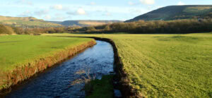
The River Bure has been navigable for some 31 miles (50 km) as far as Horstead Mill, near Coltishall, since at least 1685, when cargoes of coal, corn and timber were carried to within 1 mile of Meyton Manor House. It was stated at the time that the river could be improved to enable boats to reach the house. Vessels could not travel beyond Coltishall, and so Aylsham was served by carts, either loaded from wherries at Coltishall and carried north, or loaded from boats at Cromer and carried south. On the broads the main navigation areas are often marked by stakes. If you keep outside of these areas (in the shallower water) you will not be troubled by larger craft.

The larger broads and rivers are heavily used by motor cruisers and sailing yachts. On the rivers it is not only important to keep to the right hand side of the river but also to keep out of the way of larger craft whose helmsmen may not know or may choose to ignore the conventions! Also, remember that boats under sail may need to tack. Always pass behind them.

Licence Information

The waterways in this trail are managed by the Broads Authority and it is a requirement for paddlers to hold a licence. Paddle UK’s On The Water membership includes an annual licence for here as well as other waterways. When paddling, have your membership card with you as proof of licence otherwise you could face a fine. Get your digital membership card straight away with your licence and liability insurance included from www.paddleuk.org.uk . 

Safety Information

We want you to have fun and a safe paddle! Here are some helpful tips to ensure you paddle responsibly and stay safe on your journey. Please take a moment to review these important safety tips:

– Always wear a correctly sized buoyancy aid

– Carry a mobile phone – in a waterproof case

– Tell Someone Where You’re Going

– Check the weather and conditions

– Know your limits

Check out some useful blogs and e-learnings on how to keep safe

Water Safety

Navigation eLearning

Tides eLearning

Weather eLearning

Environment

Wherever and however you paddle, our Paddlers’ Code helps to ensure we can all enjoy and share the water safely and protect our precious environment.

Don’t get sick doing what you love. We know water quality is a concern for many paddlers. Click here for some simple advice on water quality and how to protect yourself.

Get informed, stay safe and make good decisions by checking the National Storm Overflow Map

Paddlers can play a vital role in keeping our waters free of harmful non-native species. It is crucial you Check, Clean and Dry you boat and equipment to prevent the spread. Click here for more information on Invasive Non-Native Species.

For more environmental advice and guidance, see our Blue Space Blogs section on the Paddle UK website.

Video