Erewash Canal Trail Part 2: Ilkeston to Trent Lock Paddle Trail

Erewash Canal Trail Part 2: Ilkeston to Trent Lock Paddle Trail

1-2 hours
Duration
6.5 miles
Distance
One Way
Easy
Difficulty
DE7 5BP
Start Postcode
NG10 2FY
End Postcode
A. Setting off from Gallows Inn paddle with the tow path to your left. The canal skirts playing fields, with the River Erewash meandering out of sight just past the sports pitches.

B. Easy portage at Hallam Fields Lock (No 66) – beware of rough edges on the banking.

C. A small widening of the canal represents its junction with the Nutbrook Canal. Built to service the collieries at Shipley, the Nutbrook Canal was beset with issues, closing in 1895 due to competition from the railway.

D. Easy portage at Stanton Lock (No 65), the canal passes under the M1 motorway. After passing the motorway there are views over the open countryside of the Nottinghamshire/Derbyshire border and the church at Sandiacre.

E. Pastures Lock (No64). The easiest get in after the lock is a little way downstream on a grass bank. The route passes Springfield Mill, an attractive lace mill, built in 1888.

F. The get out at Sandiacre Lock (No 63) is just before the cycle barriers, with the put-in -after the lock by the bridge. The canal widens out into a small basin – this is a pretty location, and a good place for a picnic.

G. Easy portages at Dockholme Lock (No 62) and Long Eaton Lock (No 61) as the trail passes through Long Eaton, West Park is another option for a picnic stop. After passing the park, the route crosses under a variety of bridges.

H. Pass Sheetstores Basin, there are not portages, but you pass through the flood gate, which prevents flooding on the River Trent travelling up the canal into Long Eaton.

I. Arriving at Trent Lock, egress can be done along much of the bank. Trent Lock itself is a major hub on the waterways network and an attractive place to paddle, with two pubs/restaurants and tea rooms.

Discover More

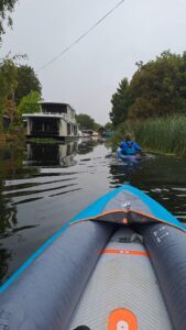
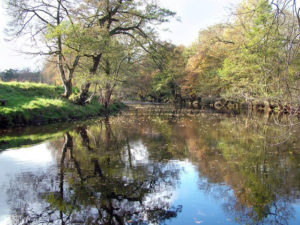
The Erewash Canal tracks along the border of Nottinghamshire and Derbyshire. With some parts urban and some rural, the canal plots a course through the area’s natural and cultural heritage. This trail covers the top section of the canal, heading from the village of Langley Mill through to Ilkeston as it passes through the Erewash Valley.

Popular with walkers, horse riders, and cyclists, the Erewash Canal also makes for an excellent paddle, combining countryside views with urban heritage.

The industrial estate opposite Hallam Fields Lock represents the beginning of a huge area that was Stanton Ironworks. Established in the 1700s, the works were once Ilkeston’s main employer. The site’s final closure came in 2007, and the area is currently under redevelopment.

At Pastures Lock, the village of Sandiacre begins to replace open countryside. The village was once a small, rural settlement but grew with the development of the textiles industry (partly facilitated by the canal). Springfield Mill is the first of several mills lining the canal through Long Eaton and has now been converted into apartments, securing its future.

Although the canal now runs through an urban setting again, it still holds charm, passing by pocket parks and washlands on the River Erewash’s flood plain. The basin is actually the previous convergence point of the Derby & Sandiacre Canal, which was fully closed in 1964, with much of its route now surviving as a public footpath. The canal has an active restoration campaign, led by the Derby and Sandiacre Canal Trust. The attractive cottages at the lock were restored and rejuvenated by another canal society, the Erewash Canal Preservation and Development Association (ECP&DA), who also restored the basin at Langley Mill. They are often opened as tea rooms or for events and serve as the base for the association.

Long Eaton, in contrast to Springfield Mill, still feels in the process of decline rather than rejuvenation—a reminder that much of our industrial heritage still needs to be saved for future generations.

Trent Lock marks the convergence of the Erewash Canal, the Soar Navigation, and the Trent Navigation, carrying goods to and from the Humber and beyond.

Facilities at Gallows Inn:

  • There is a pub, recently reopened, next to Gallows Inn Lock.

Facilities at Trent Lock:

Licence Information

The waterways in this trail are managed by the Canal & River Trust, and it is a requirement for paddlers to hold a licence. Paddle UK’s On The Water membership includes an annual licence for here as well as other waterways.

When paddling, have your membership card with you as proof of licence; otherwise, you could face a fine. Get your digital membership card straight away with your licence and liability insurance included from www.paddleuk.org.uk.

JOIN PADDLE UK

Safety Information

We want you to have fun and a safe paddle! Here are some helpful tips to ensure you paddle responsibly and stay safe on your journey. Please take a moment to review these important safety tips:

– Always wear a correctly sized buoyancy aid

– Carry a mobile phone – in a waterproof case

– Tell Someone Where You’re Going

– Check the weather and conditions

– Know your limits

Check out some useful blogs and e-learnings on how to keep safe

Water Safety

Navigation eLearning

Tides eLearning

Weather eLearning

Environment

Wherever and however you paddle, our Paddlers’ Code helps to ensure we can all enjoy and share the water safely and protect our precious environment.

Don’t get sick doing what you love. We know water quality is a concern for many paddlers. Click here for some simple advice on water quality and how to protect yourself.

Get informed, stay safe and make good decisions by checking the National Storm Overflow Map

Paddlers can play a vital role in keeping our waters free of harmful non-native species. It is crucial you Check, Clean and Dry you boat and equipment to prevent the spread. Click here for more information on Invasive Non-Native Species.

For more environmental advice and guidance, see our Blue Space Blogs section on the Paddle UK website.

Video