River Wey Navigation – Pyrford Lock to Weybridge Town Lock Paddle Trail

River Wey Navigation – Pyrford Lock to Weybridge Town Lock Paddle Trail

1-2 hours
Duration
4 miles
Distance
One Way
Moderate
Difficulty
GU23 6QW
Start Postcode
KT13 8XX
End Postcode
A. This is both an urban experience, but also more rural at times. Launch by the off road parking area and turn left, away from Pyrford Lock.

B. Pyrford Basin is close by on the left, with mooring capacity for 170 boats. After this is Dodd’s footbridge, and then Murray’s Bridge.

C. Paddle under the main A245 road bridge. West Byfleet is to your left. Continue under the Old Parvis Bridge and Byfleet Boat House, (some parking here).

D. The canal then has a long straight section, with the roar of the M25 on your right.

E. Next is the brick-built Woodham Railway Bridge, the Woodham Footbridge, and then the entrance to the Basingstoke Canal on the left.

F. Go under a metal-covered bridge, and the M25 Bridge. Between here and the lock at New Haw there are numerous moored boats at the foot of gardens backing onto the canal.

G. Portage right at New Haw Lock, opposite the small spillway (weir). This entails crossing the A318 that is usually busy and care is required.

H. It is only 0.8 miles to Coxes Lock, mostly passing houses that overlook the canal until as far as Addlestone Canoe Club, when the canal assumes a brief rural aspect.

I. Following two bends in the course of the canal brings Coxes Lock into viewm with a portage on the right. The impressive former mill on the left is now flats. When launching be aware the spill from the mill pond discharging into the pool area can create a back eddy by the lock entrance.

J. There follows a railway bridge, the Pelican pub, Blackboys Bridge, and finally the finish at Weybridge Town Lock. Land on the towpath 50 yards before the lock.

K. To keep the towpath clear, boats and kit can be moved across the road and over the footbridge to a useful area of open ground at the rear of the car park.

L. Weybridge town centre with full facilities is a five minute walk beyond the lock and over the road bridge. The trail is also suitable for a longer out and back paddle from Weybridge to Pyrford.

Discover More

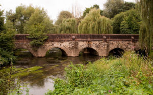
The Wey was one of the first British rivers to be made navigable and opened to barge traffic in 1653, and it is quite unusual. The Wey has two separate sources in two different counties. The two River Weys unite near the historic Tilford Oak in Surrey. The Wey and its two Navigations flow across 87 miles (140 km) of countryside, yet drop a mere 98 feet (30 m) by the time the waterway joins the Thames at Weybridge.

Start Directions: Limited off-road parking on the opposite side of the canal to the Anchor pub. The Anchor pub car park is for customers only and barrier controlled.

On the A3, travelling towards London, between Ripley and the junction with the M25, take the slip road signed for Wisley Royal Horticultural Society. Turn into Wisley Lane and continue on this minor road that leads to Pyrford Lock. Cross over the canal bridge (tight width restriction) for the limited off-road parking immediately on the left.

Or, from the A245 at West Byfleet, take the minor roads to Pyrford Green, thence to Pyrford Lock.

Finish Directions: Public car adjacent to lock (free with height restriction).

Turn off the A317 between Weybridge and Addlestone into the Bourne & Weybridge Business Park. Take the first exit at the mini roundabout that leads to the canal and Weybridge Town Lock. Opposite the lock, turn into Weystone Road for the car park. If travelling from Pyrford Lock, the most direct route is via the A3, M25 and (J11) for Chertsey, then A317 for Weybridge.

The two River Weys unite near the historic Tilford Oak in Surrey. The Wey and its two Navigations flow across 87 miles (140 km) of countryside, yet drop a mere 98 feet (30 m) by the time the waterway joins the Thames at Weybridge.

The river has been recorded in history as the Wegan (956–1225) and Waie (1190–1193). During the seventeenth century, the river was made navigable to Guildford and extended in the eighteenth century to Godalming.

The Basingstoke Canal and Wey and Arun Junction Canal were later connected to the river. The navigable sections are now owned by the National Trust.

The river has long been used as a source of power for mills, and many are recorded in the Domesday Book. At one point, there were 22 mills on the river, and more on its tributaries. At various times, they have been used for:

  • Grinding grains
  • Fulling wool
  • Rolling oats
  • Crushing cattle cake
  • Leather dressing
  • Paper production
  • Gunpowder manufacture

There were more watermills per mile along the River Wey than anywhere else in Britain. This 15½-mile waterway linked Guildford to Weybridge on the Thames, and then to London.

The Godalming Navigation opened in 1764, enabling barges to work a further four miles upriver.

The award-winning visitor centre at Dapdune Wharf in Guildford tells the story of the Navigations and the people who lived and worked on them. Visitors can see where the huge Wey barges were built and climb aboard Reliance, one of three surviving barges.

Licence Information

The waterways in this trail are managed by the National Trust and it is a requirement for paddlers to hold a licence. Paddle UK’s On The Water membership includes an annual licence for here as well as other waterways.

When paddling, have your membership card with you as proof of licence; otherwise, you could face a fine. Get your digital membership card straight away with your licence and liability insurance included from www.paddleuk.org.uk.

JOIN PADDLE UK

Safety Information

We want you to have fun and a safe paddle! Here are some helpful tips to ensure you paddle responsibly and stay safe on your journey. Please take a moment to review these important safety tips:

– Always wear a correctly sized buoyancy aid

– Carry a mobile phone – in a waterproof case

– Tell Someone Where You’re Going

– Check the weather and conditions

– Know your limits

Check out some useful blogs and e-learnings on how to keep safe

Water Safety

Navigation eLearning

Tides eLearning

Weather eLearning

Environment

Wherever and however you paddle, our Paddlers’ Code helps to ensure we can all enjoy and share the water safely and protect our precious environment.

Don’t get sick doing what you love. We know water quality is a concern for many paddlers. Click here for some simple advice on water quality and how to protect yourself.

Get informed, stay safe and make good decisions by checking the National Storm Overflow Map

Paddlers can play a vital role in keeping our waters free of harmful non-native species. It is crucial you Check, Clean and Dry you boat and equipment to prevent the spread. Click here for more information on Invasive Non-Native Species.

For more environmental advice and guidance, see our Blue Space Blogs section on the Paddle UK website.

Video